
Overview
This ride is ideal for anyone visiting the western Algarve and staying in the Lagos or Portimão area. It could be tackled as a tough one-day ride, or split into two with an overnight stop in the Monchique area.
The ride has been recommended by fellow cyclist and Algarve resident Andy Smallwood, who says many cycling groups use the extension to the summit of Fóia as a training ride.
Distance & difficulty
This will be a tough ride for most riders. The total distance is about 93km (56 miles) but – more crucially – it starts practically at sea level.
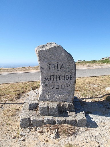
The village of Monchique is at an elevation of about 450m and if you go all the way to the summit of Fóia that’s at 902m!

Facilities
You’ll find cafes and shops in any of the small towns near the start of the ride – Odiaxere, Mexihoera Grande and Figueira – as well as in Monchique and Marmalete.
If you want to split the ride into two, then there’s a range of accommodation in and around Monchique, as well as at Caldas da Monchique. The bigger towns nearby – Lagos and Portimão – offer a wide range of accommodation and eating options, as well as supermarkets, bike shops etc.
Click on Listings to search for accommodation, bike hire, weather forecasts etc…
Detailed description
The map for this route begins in the village of Mexilhoeira Grande but anywhere between Odiaxere and Mexilhoeira will do just as well – the important thing is to give yourself a bit of a warm up before starting the climb.
Heading north away from the start, you’re very quickly on country roads and into lovely scenery.
From January on, not only are the fields around here at their greenest but you’ll see drifts of almond blossom appearing everywhere and the spring flowers won’t be far behind.
The first 15km or so of the ride are fairly gentle. After turning onto the N266, the ascent quickly starts to increase. There are wooded hills on both sides and you’ll be climbing steadily.
After about another 8km, you reach the small spa centre of Caldas da Monchique – which has hotels and a restaurant as well as places to sooth any aching muscles!
Caldas is at an elevation of about 240m. From there you’ve got about another 7km and around 200m of climbing to reach Monchique itself – a small hill town famous for its smoked ham.
You could turn back here – in fact there’s no need to go to Monchique at all. After Caldas, you can turn left on the N267 and save yourself 4km of climbing. But then you wouldn’t get to enjoy the downhill return journey.
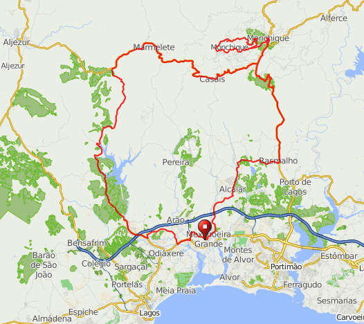
From Monchique, it’s a 14km round trip to reach the top of Fóia. I’ve shown a circular route here but you are strongly advised to take the southern road N263-3 on the ascent and go clockwise as the alternative would be a real killer for anyone who isn’t super fit. (Unfortunately, if you want to get to the top then your bike is probably the only option – there are no buses!)
After descending to Monchique*, retrace your steps to the junction with the N267, which then takes you on a relatively level route towards the village of Marmelete – the road isn’t flat but you’ll be staying fairly close to the 400m contour line most of the way – gradually rising to 500m. (*Note: the descent from Foia shown on the map takes you via a minor road that is paved but has steep sections with some loose gravel. For a smoother and gentler way down from the summit, go back the same way that you went up.)
There are wonderful views as the road wriggles its way west, gradually descending to Marmelete. Keep going for about another 5.5km and then turn south towards the Barragem da Bravura. (For some reason, Google identifies the lake as the Barragem de Odiaxere but it’s more commonly known, and signposted as, the Barragem da Bravura.) It’s then downhill out of the trees and into quiet countryside for the final run down towards Odiaxere and back to the start.
You can either go into Odiaxere or take the route shown on the map, which takes you via some tiny back lanes. Either way, you’ll have to ride for a short distance on the N125, which can be busy, although there is a reasonably wide shoulder.

I rode this route and it was absolutely brilliant. I broke it into two pieces with an overnight stay in Monchique. The weather was also stunning so it was just the most perfect way to spend New Year’s Eve/New Year’s Day.
Hi – I’m keen to tackle this ride ‘Monchique Explorer’ one day between Sat 7th April 2018 – Mon 9th April 2018 if anyone is interested to join me? A long shot i know but you never know! I’m from Australia an am visiting Portugal at this time.
Hi Mick.
I don’t have any local contacts but you’re probably best putting a post on a local Facebook site or expat forum if you can find one.
Cheers, Huw
Hi! I’m interested in the Monchique Explorer ride, but I don’t see the actual route on the map. Is there some more detailed place where we can get instructions on where to start, which roads to take, etc? Thanks!
Hi. Sorry – the map got corrupted when Google Maps updated their system (grrrr). I have now created a new map using ridewithgps.com – click on the link and this will also give you a full ride profile showing inclines.
Cheers, Huw