Overview

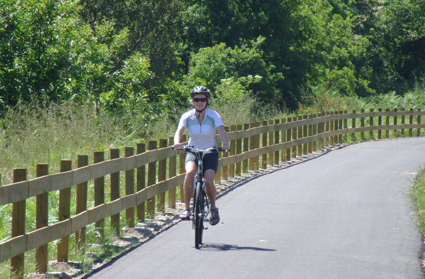
The Ecopista do Dão is a 49km section of old railway running between Santa Comba Dão and Viseu.
It’s all sealed and the gradients are gentle. It’s a lovely, traffic-free way to see some of the countryside and villages in one of the most attractive areas of rural Portugal.
There are plenty of places to access the northern half of the route between Viseu and Tondela – and it would be easy to incorporate part of the ecopista into a local route.
I’ve also used it as an optional short cut for the end of my Viseu Villages ride.
South of Tondela, the route only crosses a couple of roads. Getting to/from the southern end of the ecopista near Santa Comba itself is still a bit tricky – see section below on access.
The short YouTube video below will give you a taste of the route and some of the scenery along the way:
Access
Officially, the ecopista starts near Santa Comba Dão and finishes at Viseu. It’s possible to access the trail at various points along the way, including at a number of old stations that once served villages along its route.
For many years getting to/from the start was very difficult. The ecopista begins where the former railway branch line split from the still operational main line. However, there never used to be any signage telling riders how to get to/from the start – and the only road bridge crossing the Dão river was closed to cyclists.
Things have improved – although they are still not perfect. Cyclists are now allowed on the IP2 to cross the Dão. Be warned though that it’s a very busy road and the bridge is fairly narrow with only a small shoulder.
Brown signs for the Ecopista do Dão now direct you from the IP2 onto the old N2 and up to Santa Comba Dão railway station. From here it gets a lot less obvious!

Riders need to turn left from the car park by the station building and go about 300m along the platform to the far end. Here, a sign that’s impossible to see from any distance, directs you down a rough path and along a dirt track for another 200m to the official start of the ecopista (see images below).
If going the other way, turn right at the end of the ecopista and follow the path parallel with the railway above. Then follow the signs and go up a steep and rough (but short) section onto the platform. Turn right and follow the platform.

Alternatively, one other option is to start/come off the cycle route at the old Trexeido station – just upstream from where the ecopista crosses the Dão. From here, there’s a road (and a good hill) up to the village of Trexeido, from where the CM1564 goes back down to the river and into Santa Comba via the village of Granjal.
The only other possibility is to take the old N2 stone bridge over the Dão – but this is only possible when water levels are not too high. The Dão has been dammed downstream and at times the old bridge may be underwater. However, it’s normally above the surface (see picture below). The bridge is just downstream of the IP2 bridge.

To get to the old bridge from Santa Comba, go under the IP2 towards Granjal but then turn right towards the IP2 bridge. There’s a flight of steps up on the other side but a gap in the barrier provides access to the old N2.
Coming from the station, follow the N2 as it loops down and under the IP2 and look for the steps opposite the parking area.
Maps
The map below shows the ecopista using Open Street Map (and RideWithGPS). Be aware though that while most online maps recgnise the ecopista, Google Maps is still catching up!
Most of it shows up on Google Maps but frustratingly it doesn’t recognise a bridge at Mosteirinho, where the original viaduct was rebuilt in 2009 for cyclists and walkers, literally taking you over part of the village, or a section south of Farminhão, where the path goes through a long tunnel (just about okay without lights!).
At Figueiro (west of Viseu) there is also a long cutting and short tunnel (under the N337-1) that also doesn’t show up online. Both the viaduct at Mosteirinho and Figueiro can be clearly seen if you look at the map with the satellite view.
Distance & difficulty
The total distance is about 49km (31 miles) and the cycling is easy going and mostly downhill from Viseu to Santa Comba. Coming the other way there’s a fairly long climb from Dão valley to Tondela but – being an old railway – the gradient is steady and gentle.
Facilities
Although there were originally no cafes actually on the ecopista, some of the old stations have now been converted. I’m not sure how many of these operate year-round or full-time. Otherwise, the route goes through various villages where a short detour should take you to somewhere open.
Viseu is the main town of the region with plenty of shops, supermarkets, cafes, restaurants and a wide range of accommodation. Tondela and Santa Comba Dão are also both reasonable sized towns with various shops, cafes etc.
If you want to find a cafe close to the ecopista, villages to try include Tondelinha, Figueiro, Mosteirinho, Torredeita, Farminhão and Sabugosa.
Click on Listings to search for accommodation, bike hire, weather forecasts etc…
Detailed description
The original section between Viseu and the station at Figueiro is quite pretty. However, the large number of chicanes installed to prevent cars driving along the trail can make it a bit frustrating.
Some of these are tricky to negotiate without dismounting and in some places – particularly just outside Viseu – there seems to be a chicane every few hundred metres!
Fortunately, there are none on the rest of the ecopista – although there are some very rough ‘rumble strips’ made of granite cobbles. Their placement is fairly random – they’re at some places where minor roads cross the cycle route but not at other, more major crossings.
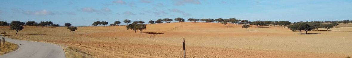
The section from Figueiro to Farminhão is probably the prettiest part of the ride with views over fields, woods, small villages and towards the Serra do Caramulo. There’s a long tunnel just south of Farminhão – just keep cycling towards the light and you’ll be fine!
The ecopista winds around through more woods and countryside to the old Tondela station (which is nowhere near the town centre). There’s then a long and very beautiful drop to the Dão valley. There are a couple of old stations along the way but nothing else.
After crossing the Dão, the final section follows the river for about five km. Where the old railway line meets the modern one, there’s a rough track taking you to Santa Comba Dão Railway Station. (See notes above on access).
Huw & Carolyn Thomas, February 2012.

2 thoughts on “Ecopista do Dao”